Day Six
Saturday, 09-04-04
We rose and mounted up in the dark. I was fairly certain that there was a marker for the Jacksboro Station so we went looking for it. I don’t think we would have found it but we met a policeman coming out of his house. I approached him and he was familiar with the plaque. He was happy to lead us over to the bridge and the marker. N33° 12.869' 98° 9.523'
We headed west on Monument Road towards Winn-Hill Cemetery. It was a great early morning ride.  Greene describes it as “one of the most interesting parts of the westering pathways” Isolated and with fewer people than there were in 1858. We made our way to the cemetery and onward. Monument Road has several historic sites. Starting with Fort Richardson in Jacksboro. The fort was established in 1867 on the already established road. It served to defend against the Comanche and Kiowas which clashed with the ongoing movement of settlers after the Civil War.
Monument Road which connects to Turtle Hole Road and LC Young Gravel Road all closely follow the original Butterfield. We saw markers for the Warren Wagon Train Massacre of 1872 and a mention of the Turtle Hole. Turtle hole was supposed to be Two miles west of Murphy’s. There was no sign of Murphy’s Station though is should be right off Highway 16 at Turtle Hole Road. N33° 12.326' W98° 30.445'The gravel road was reasonable and the set and setting transported us literally and figuratively as we made our we made our way towards Fort Belknap on what was once known as the Old Fort Griffin to Jacksboro Road.
Turtle Hole, a crossing and spring-fed waterhole on the Butterfield Overland Mail stage route, is on Turtle Hole Creek 12 miles east of Fort Belknap. “The reliable source of water made Turtle Hole a popular camping place. In January 1871 it was the site of a fatal attack by Kiowas under Maman-ti on black freighters delivering flour to Fort Griffin, led by scout and frontiersman Britton Johnson and two companions, Dennis Cureton and "Paint" Crawford. This event was of sufficient importance to be commemorated on at least three of the Kiowa buffalo hide calendars. Lt. Robert G. Carter, adjutant to Col. Ranald S. Mackenzie, commander at Fort Richardson, referred to the crossing as "Dead Man's Cross" because of the attack there. Mackenzie, as well as later travelers, noted seeing the graves near the attack site.” Turtle Creek was pretty dry when we passed over it.
Fort Belknap Station N33° 9.057' W98° 44.453'
We worked our way over to Fort Belknap Park via Newcastle. The trail from Jacksboro to Fort Phantom hill is quite interrupted now by cattle fences and though much can be traveled it requires some back tracking.
At Belknap we found well preserved buildings and a water well dated 1858. It is always fun to see something still standing that was in all likelihood standing for the first Butterfield run. There was a great museum there and the look and feel of the place was very rewarding. The road left the park headed due west towards the Brazos but does not cross now so we took improved road out of the park and towards the next station. Greene notes that there was a seam of bituminous coal here which provided cola for some of the stations.
Franz’s Station N33° 2.676' W99° 3.336'
We headed for Woodson and then went north a bit to look for the ruins of the home of James Madison “Uncle Mat” Franz. 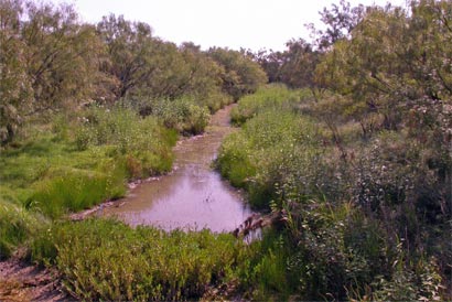 Greene says it can be seen from 1710 as a pile of stones near the right of way of the abandon railroad on the banks of the Middle Fork. We found the railroad bed and the Middle Fork but could not locate the ruins. Here’s the Middle Fork near the Railroad.
Clear Fork Station
The next station has a pretty good description. “Clear Fork of the Brazos. Between Old Camp Cooper and Fort Griffin. Near the confluence of the Clear Fork and Lambshead Creek. John G. Irwin and T. E. Jackson and later Uncle Mat Franz. The road left here following the north bank of Lambshead. No through route cause of ranches. No Obvious route to Smith’s. .Can be accessed with permission and the well is still there. Much of the trail can be seen (from the air) as it crosses the vast Lambshead Ranch. 26 miles Clear Fork to Smith’s”.
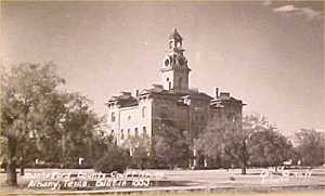 Because much of the route is not accessible through the Lambshead ranch, we elected to go through Fort Griffin and down through Albany . The County Courthouse was beautiful in the distance but we made time through Albany and on to a plaque at the Bud Mathews Ranch.
Smith’s Station and Spring. N32° 42.727' W99° 31.317'
Take 180 west 11 miles from Albany there is a simple marker at the site. The trail continues SW into the Old Conrad Place. You can actually drive the old trail here thanks to a late owner. The Rock Chimney has been reconstructed and the site preserved. On the East side of Chimney Rock Creek. There is a Chimney Rock Ranch marked on the east side in a general line between Phantom Hill and Clear Fork’ no through route really. Trail continued SW across the Buck-nail Ranch. You can go south on Chimney Creek Ranch Road and west across Buck-Nail to Rising Sun Cemetery and then the old mail road crosses Deadman Creek. Take Buck Nail Ranch road to Rising Sun cemetery. Then across Deadman. It becomes E Nuggent Rd. Smith’s to phantom 12 miles. We decided to keep on blacktop here and stayed on 180 until we got to the road south to Nugent.
This road led to Fort Phantom Hill Station N32° 38.876' W99° 40.632'
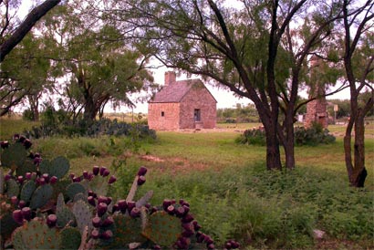
This was one of our most memorable stops. The station took over the ruins of Fort Phantom Hill which was abandoned in 1854 and utilized some remaining structures for the Station.
What remains today are several very well preserved buildings including this sturdy munitions house which was used to store supplies.
The actual Station at Fort Phantom Hill was in this delightful setting.
I remember this next image quite clearly. I had seen it somewhere in a book or something. As Paul and I approached Fort Phantom Hill there was a moment of confusion and I tried to place this image and at the same time pull into a parking lot.
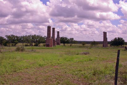
Unfortunately, as I approached the parking lot, because I was looking at these chimneys, I failed to notice it was the “lower” parking lot and the entrance was blocked by a sizable chain stretched across its entire length. Paul was not so fortunate either, for he saw the chain, but had no way to warn me of impending disaster and so could only watch in paralyzed horror as I proceeded into my inevitable collision.
Now what seems remarkable in hindsight is that I am able to tell the tale at all. Yet, here I sit remembering, as in a dream, that at some level I knew in that striking moment that “something” was happening. There was a distraction of sorts, I knew that. How close I came to total extinction is hard to say. What is certain is that if that chain had been fastened by anything more substantial than a piece of rusty bailing wire a more dramatic description would be necessary . In the end though, my distraction from the view above was a mere flick and a tug as I bolted through the obstruction. I realized that we were in the wrong parking lot. Then I realized, as my life flashed before me, that I very nearly could have ended the trip right there.
I secured the chain and headed up to view the ruins.
We spent time here. It had a eerie other world or maybe after world feeling. We didn’t talk about my brush with chain-induced death. We relaxed in our good fortune, examined some artifacts and in good male fashion pretended nothing had happened.  What went through my mind later was, “If you are born to be hanged, you’ll never drown.” I, of course, have no idea where that came from or what for sure it really means.
We both knew though that I had cheated death
and had only Our Lady of Guadalupe to give thanks.
We continued on renewed in our efforts to keep a careful eye on the road.
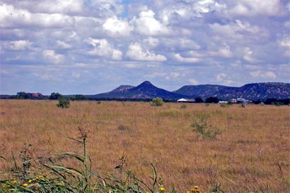
Our next stop lay out across the plain before us. A famous landmark that guided a century of travelers and pulled us both back to the road: Castle Peak. Castle Peak is seen here in the distance. It's the pointy one.
The road took us around Abilene and through Tye where there was a marker noting the Butterfield. We headed toward Mountain Pass Station N32° 18.471' W100° 3.170' but the road was block to us as it headed into Rhodes Ranch. We had to track around the Valley Creek Station N32° 9.352' W100° 8.065' but were rewarded with Fort Chabourne.
Fort Chadbourne Station N32° 2.070'W100° 14.805' is privately owned and I couldn’t help but feel empathy for the industrious caretaker that we watched moving things around with his back hoe. Click here for a virtual tour

The museum was closed the day we were there and in spite of the heat we wandered for better than an hour.
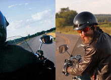
 Enjoying the fort and taking pictures we posed for the quintessential boys on bikes portrait

In the ruins we also found this reminder.
Albert
Haneman
Oct 19, 1858
Who is Albert Haneman?
New info click here
We talked a bit with the steward of this place. He asked us if we thought he was crazy for pouring his heart and soul and all his resource into restoring it. I could honestly look him in the eye and just say, thanks.
We made a run to San Angelo from here. Staying on blacktop and we missed Grape Creek Station, N31° 42.475' W100° 32.765' but we’re glad to have a place to put our heads.
We stopped at 5:00 pm after 307 miles for the day at a moving rate of 40 miles an hour. Seven hours of travel, four hours stopped, and a total of 1305 miles so far.
posted by Don and Paul Matt at 6:46 AM
0 comments
![]()